
Thanks to Marion “Monk” Moore and Joan Howell Waddell, I’ve been able to identify the approximate locations of several of the white farmer-landowners listed near Willis and Cherry Battle Barnes in the 1870 census. If the family remained in the general area in which they had been enslaved, Hugh B. Johnston’s speculation is correct.
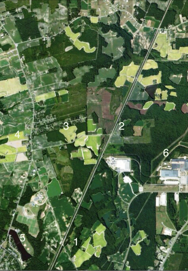
Toisnot Reservoir, a dammed stretch of Toisnot Swamp, today lies on the northern edge of the city of Wilson. Joshua Barnes, Alpheus Branch, Ceborn Farmer, Isaac Farmer and Jesse Farmer’s farms all lay north of the swamp and south of present-day Elm City in a corridor now defined by London Church Road, the CSX Railroad (then the Wilmington & Weldon) and US Highway 301. The Barneses lived somewhere in this area. In the photo above, the diagonal running top to bottom is the railroad, London Church Road bows to the left, and numbers mark the approximate locations of farms and modern landmarks: (1) Isaac Farmer land; (2) Seborn Farmer land; (3) Alpheus Branch land; (4) Joshua Barnes land; (5) Toisnot Reservoir; and (6) the Bridgestone-Firestone tire plant.
——
In a letter dated 11 January 2007, Waddell included a map of Wilson County with the above properties marked. Many thanks to her and Monk Moore.
——
Update, 23 June 2015: Joshua Barnes’ house is not only still standing, it’s been continuously occupied since the 1840s and was on the market just a few years ago. It’s located at 3415 London Church Road.


Pingback: United in matrimony: Barnes. | Scuffalong: Genealogy.