Land, Newspaper Articles, Paternal Kin, Photographs

Indiana Chronicles, no. 3: Dock Simmons’ Logansport.

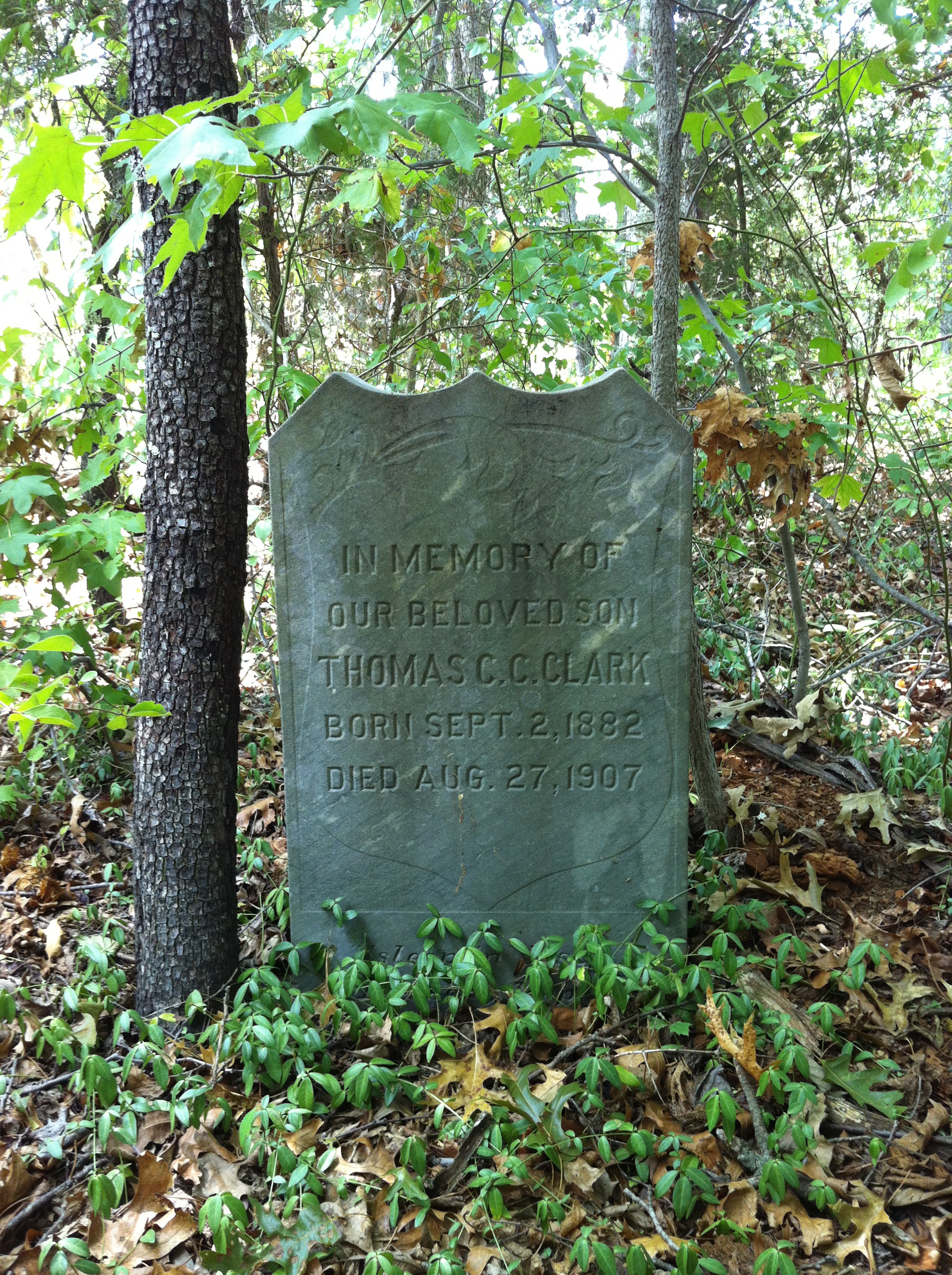
As discussed here, in 1900, Doctor T. “Dock” Simmons went in with his father Montraville to purchase 138 acres in Noble township, Cass County.

Things did not go well.

On 9 June 1901, the Logansport Pharos-Tribune reported “Trouble on Watts Farm: Father and Son Cannot Agree on Conducting Affairs.” Dock and Montraville argued as Dock was preparing to take his “best girl” to church. A few days later, Dock proposed to “go and leave the farm forever, giving his father his interest, if he would allow him to take his team [of three horses] away.” “To this the father objected, but the son, tired as he says of the unpleasant conditions that have prevailed on the farm for some time, was determined to leave, and in spite of his father’s threats, hitched up a team and drove to town.” Montraville jumped on a horse, passed Dock on the way into Logansport, and went to the police station. As Dock passed, a police officer ordered him to come in. He and his father then agreed to drop the matter and went back to the farm. Barely two hours later, Dock re-appeared at the station “with a bleeding head and a lump on his cheek” and accused his father of hitting him with a rock. He did not to press charges, however, and the police advised him to go home and “patch up the matter as best he could.” “It is likely that young Simmons will sue for the division of the property which consists of 140 acres.” He apparently did not.  A 9 June 1905 Pharos-Tribune article reported that the Watts farm owned and operated by Montraville, Dock and Montraville Simmons Jr. had been sold at sheriff’s auction to satisfy a $3000 judgment against “the Simmons people.” Somehow, though, they got the land back.

On 26 August 1901, Dock Simmons and Fannie Gibson were married by a Justice of the Peace in Logansport.

PT 8 26 1901

Logansport Pharos-Tribune, 26 August 1901.

The couple made their home in town, away from Dock’s bullying father, as on 26 September the Logansport Daily Report briefly mentioned that Fannie was very sick at their Park Avenue home.  Two months later, on 15 August, Dock was horribly scalded by steam from a blown-out traction engine while working at the farm with his brother (probably Edward). A newspaper article mentioned that Dock, who lived on Helm Street, was confined to his father’s home with terrible burns. A different paper, the Logansport Daily Report, said he lived on “Lockwood street, West Side,” a statement that lines up with the 1905 Logansport city directory: w[est] s[ide] Lockwood 1 [block] s[outh] Melbourne av.”

1905 Dock

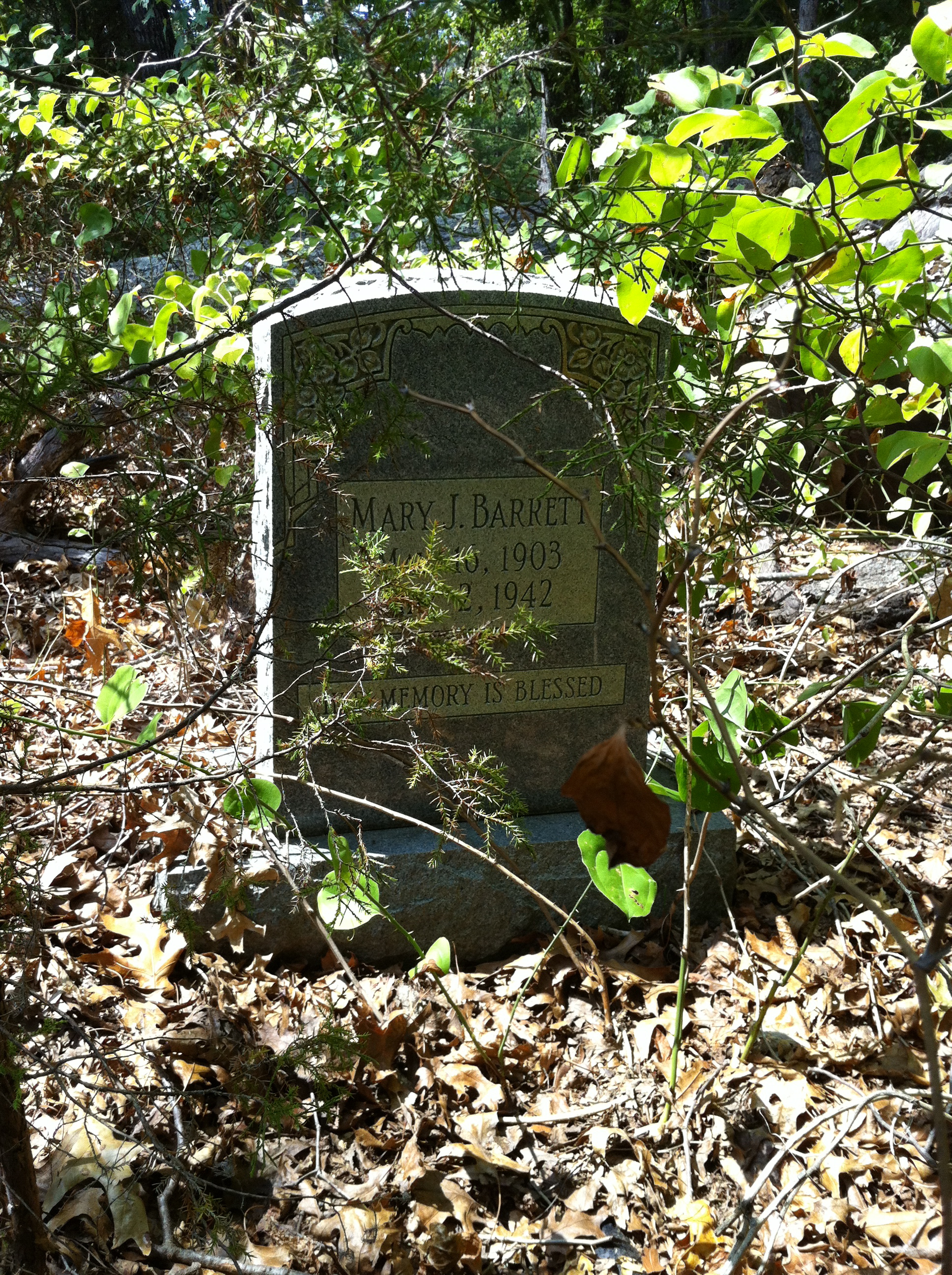
In the 1910 census, Dock and Fannie appear at yet another address: 57 Seybold Street. However, on 6 January of that year, the Pharos-Tribune reported that Fannie had broken her arm in a fall in her yard “two miles west of the city on the Wabash river road.” And on 28 May, when Dock was robbed by a female highwayman, the Daily Tribune described him as a Dunkirk resident. Then on 7 February 1911, in describing an accident in which Dock was knocked from his wagon by a streetcar, the Pharos-Tribuine gave his address as Park Street. It is not until about 1920 that the Simmonses’ address achieves regularity at 129 Seybold Street.

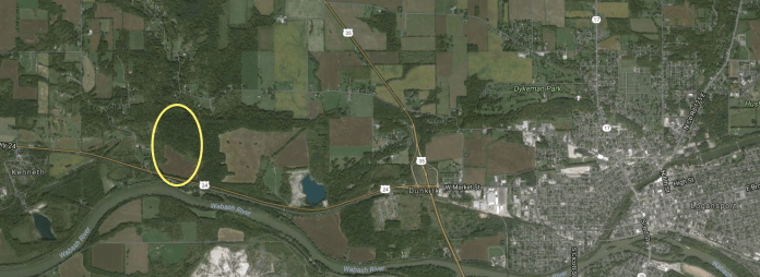
What is going on here??? Were Fannie and Dock really bouncing around Logansport every few months? No, and a modern map of Logansport helps explain. The oldest section of town, shown here underlying the city’s name, formed at the junction of the Eel and Wabash Rivers. The area across the Eel from the city’s point was known as its West Side.  This neighborhood, at A, is informally bounded by the old Vandalia railroad tracks. Market Street is the major thoroughfare shown snaking across the city. It becomes West Market as it crosses west over the Eel. (The spot marked B is approximately where Dock was robbed by the Lady Bandit.) Dunkirk, shown here at C, is an unincorporated community just west of the city. (The Simmons’ farm was a few miles beyond Dunkirk.)

IMG_9555

Here’s a closer look at the west side of the West Side. All the streets named as habitats for Dock and Fannie Simmons — Helm Street, Lockwood Street, Park Avenue, Seybold Street, and Wabash River Road (now West Wabash Avenue) — form a two-block rectangle. It’s possible that they occupied several houses in these blocks before finally settling at 129 Seybold, but it’s more likely that the inconsistencies were the result of the use of a street name to designate an area, rather than a precise address, and they were in the same house the whole time.

IMG_9554

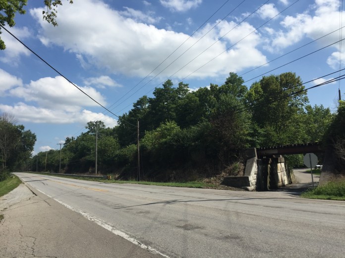
Dock and Fannie seem to have lived at 129 Seybold until the end of their days, and the house, built about 1900, remains home to a Logansport family.

IMG_9466.jpg

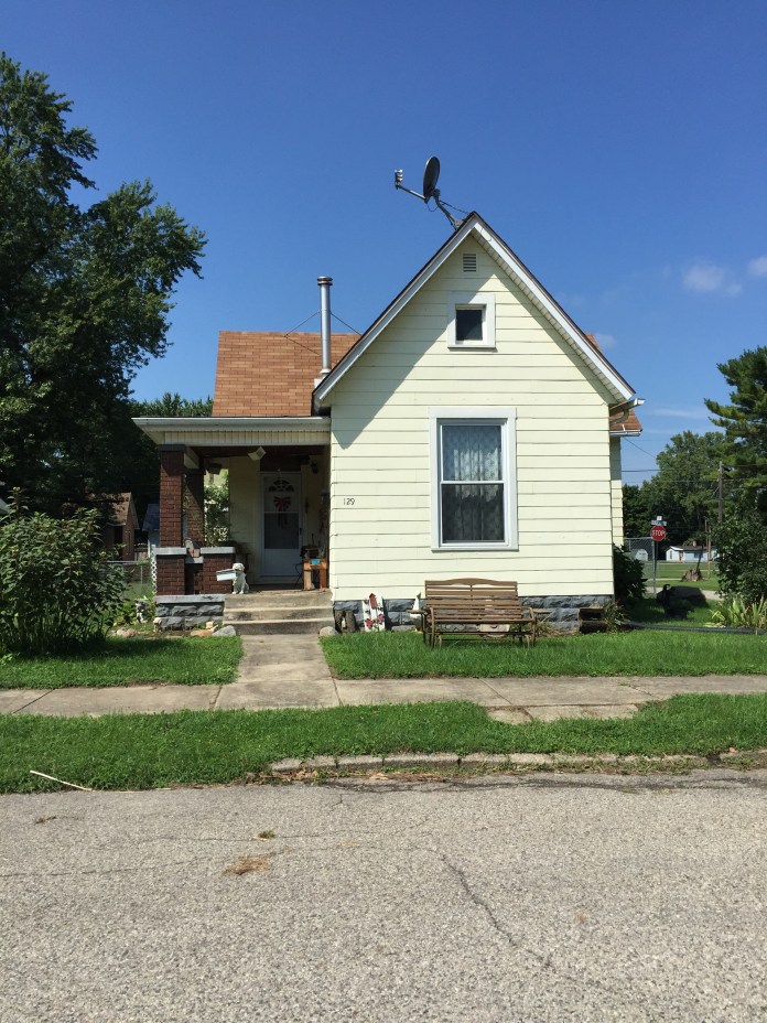
Photograph by Lisa Y. Henderson, August 2016.


Standard
Free People of Color, Land, Migration, Paternal Kin

Indiana Chronicles, no. 1: East half and Northwest quarter of Section 29, Township 27 North, Range 1 East.

On 10 April 1900, Montraville Simmons and Dock Simmons of Howard County, Indiana, paid $6000 to the heirs of Israel Watts for this real estate:

Beginning at the North-west corner of said Section; thence West Twenty-eight -28- chains and Eighty-two -82- links to a stone; thence South Twenty-eight -28- chains and Seventy-one -71-links to a stone on the North Bank of the Wabash and Erie Canal; thence Westwardly along the North line of the Wabash and Erie Canal Eighteen -18- chains and Sixty-three -63- links to the East line of the Public Highway; thence South eastwardly along the East line of the Public Highway to the North Bank of the Wabash River; thence Eastwardly along the North line or meanderings of said Wabash River to the East line of said Section Twenty-nine -29-; thence North along the East line of said Section to the place of beginning, containing in said tract One Hundred and thirty-eight -138- acres, more or less.

Excepting from the Warranty the Wabash and Erie Canal and the P.C.C. and St.L.R.R. Co. right-of-way.

The decade that the family held the “Old Watts Farm” was a non-stop circus of squabbling with neighbors, domestic abuse and ruinous mortgages. (More on all that later.) In the middle of it all, Anna Henderson Simmons lay her burden down. After a few years tied up in Anna’s probate, and the deaths of Montraville Sr. and Jr., the property passed out of the Simmonses’ hands.

Astonishingly, though, the parcel is largely intact. Here it is in an undated (but perhaps mid 1930s) Cass County, Indiana Plat Book and Atlas, found at the Cass County Public Library:

IMG_9503

And a 1951 map of Cass County prepared by Charles D. Murphy, Cass County surveyor (also found at the library):

IMG_9499

And an up-to-date county plat map hanging in the Cass County Recorder’s Office:

IMG_9457

And in a screen-capture from Google Maps:

Screen Shot 2016-08-26 at 7.27.31 PM

Highway 24 cuts across the bottom of the property running alongside the railroad (formerly owned by Pittsburgh, Cincinnati, Chicago & Saint Louis Railroad.) It’s difficult to tell where the canal once ran. Presently, there’s no road off 24 leading into the Simmons farm. However, if, headed west, you hang a sharp left onto Georgetown Road, you’ll pass under the railroad trestle and, on the left as the road curves to follow the Wabash River, you’ll see a private driveway that leads into what was Montreville’s riverfront. (Now occupied by Morels on the Wabash, offering cabins and campsites.)

IMG_9508

Looking across Highway 24 to the trestle over Georgetown Road. The land stretching away to the left (east) was Montreville Simmons’.

IMG_9490.JPG

The Wabash River looking west.

Metes and bounds set forth in deed (that I copied, but neglected to write down the book and page numbers for), Cass County Recorder’s Office; photographs by Lisa Y. Henderson, August 2016.

Standard
Land, North Carolina, Other Documents, Paternal Kin

Country roads, Nahunta.

This is a section of a 1904 topographical map of parts of Wilson and Wayne Counties, North Carolina. I am amazed at how much of the blueprint, so to speak, of Nahunta, is the same. More than one hundred years ago, kinfolk traveling from Wilson to Eureka or Fremont would have taken the same roads that I drive now. Today these roads are paved, but the paths they cut over branches and through fields across the countryside have otherwise changed little.

wilson-1904_lnr copy 2

1. Turner Swamp Road runs from the crossroads at the center of Eureka northwest to dead-end at Davis Mill Road (9). Jonah Williams‘ church is on this road, and his brother Richard Artis’ family were among early members.

2. Reidtown Road arcs to connect Highway 222 and Turner Swamp Road. It is named for the community formed by the Reid family, free people of color who settled here as early as the 1830s and intermarried with Artises.

3. Napoleon Road, a spur off Reidtown Road, now cuts across Aycock Swamp to meet Davis Mill Road. It remains unpaved, and the only house standing on it is the one Napoleon Hagans built in the 1870s or ’80s. I believe the speck to the left of the road’s end on this map is Hagans’ house.

4. NC 111, which runs with NC 222 northeast to NC 58 at Stantonsburg in Wilson County.

5. NC 222.

6. Black Creek Road connects Fremont (via its Old Black Creek Road spur) and the town of Black Creek in Wilson County. (Black Creek was once the northernmost section of Wayne.) The road is called Frank Price Church Road in Wilson County.

7. Lindell Road runs from Faro Road (8), just south of Eureka, east into Greene County’s Bullhead district. Much of Adam Artis‘ land lay between NC 111 and Lindell Road.

8. Faro Road, the continuation of Turner Swamp Road, runs south from Eureka toward the unincorporated community of Faro, famous as the site where two hydrogen bombs dropped when a B-52 broke up in flight in 1961.

9. Davis Mill Road arcs from Fremont as the northernmost east-west artery across Nahunta.

Standard
Agriculture, Land, North Carolina, Other Documents, Paternal Kin, Photographs

Swamps and sandy loams.

This is what dirt looks like where I’m from. It is not the plush black alluvial loam of the Mississippi Delta or the thin, rock-bedeviled soil of New England. It looks, mostly, like sand. Like in this graveyard, just south of Stantonsburg, Wilson County, where some of my Hall collateral kin lie. IMG_2195 The landscape of my childhood was level. Pine trees and flatness. Devoid, I thought, of any markers of geographical history. No boulder-strewn outcroppings, no foreboding hills, no deep-cut canyons. However, to the contrary, the most obvious relic of deep time was right under my feet.

I grew up on the western edge of North Carolina’s Coastal Plain, which was once the ocean floor. What looked like sand thrown up into the heels of my sneakers in fact was. The story wasn’t quite that simple though. I recall that patches of dirt in some places — like my parents’ back yard — are a pale gray, while others are the soft yellow of the Hall graveyard or, in veins here and there, the rusty-red of clay.

A few days ago, I found a soil survey map of Wayne County, North Carolina, dated 1916. Wayne, where my father’s mother’s people have lived since beyond memory, is just south of my home county. Seldom do I visit my parents that I don’t hop in the car for a quick dip down there. It’s a mere ten miles to the northern corner where my Artises and Haganses and Seaberrys lived, and just another 30 to get down to Dudley, where my Hendersons and Aldridges took root. What could this map, with its colorful camouflagey swirls of color, tell me about their land? The soil from which they pulled sweet potatoes and collards and the cotton and tobacco that put money in their pockets?

Screen Shot 2015-07-14 at 9.53.24 PM

Here’s Nahunta, with Fremont at far left and Eureka at right. The road crossing from edge to edge is now known as Highway 222, and I have cousins that still live on it. That brownish sickle under N A H is marked S, which the key tells us is “Swamp.” Specifically, this is Aycock Swamp, upon whose banks Napoleon Hagans built his house. Another bit of S juts between U and N — that’s the tail end of Turner Swamp. And reaching in from Greene County is the swamp that envelops Watery Branch. Screen Shot 2015-07-14 at 9.49.48 PM Just below Eureka is a blob of Nv, “Norfolk very fine sandy loam.” The greenish Nf that dominates the frame is “Norfolk fine sandy loam.” This is Adam Artis territory. The pale lavender-gray that washes across the middle is plain “Norfolk sandy loam,” Nl. The only color left in the areas in which my family lived is the sliver of peach that hugs the south side of Aycock Swamp — Ps or “Portsmouth sandy loam.” What is all this?

From a very helpful PDF linked to the pittcountync.gov website: “The Norfolk series consists of well-drained, nearly level and gently sloping soils on uplands. These soils formed in Coastal Plain sediment. A seasonal high water table is below a depth of 5 feet. In a typical profile, the surface layer is dark grayish-brown and light yellowish-brown sandy loam about 10 inches thick. The subsoil is olive yellow and brownish yellow to a depth of about 84 inches. In the upper part, the subsoil is friable sandy clay loam mottled with red. In the lower part, it is friable sandy loam mottled with red and gray. Natural fertility and the content of organic matter are low, and available water capacity is medium. Permeability is moderate, and shrink-swell potential is low. In areas that have not received lime, reaction is strongly acid or very strongly acid. The Norfolk soils of Pitt County are important for farming. Slope is the major limitation to their use. Most of the acreage is cultivated or in pasture. The rest is chiefly in forest and in housing developments or other nonfarm uses. Where crops are grown, response is good to recommended applications of fertilizer and lime.” (Pitt County is on the other side of Greene from Wayne County.)

From the same source:  “The Portsmouth series consists of very poorly drained, nearly level soils on stream terraces. These soils formed in alluvial sediment. A seasonal high water table is at or near the surface. In a typical profile, the surface layer is very dark gray and very dark grayish-brown loam about 15 inches thick. The subsoil is about 24 inches thick. The upper part is grayish-brown, friable sandy loam mottled with grayish brown. The lower part is grayish-brown, friable, sandy clay loam mottled with yellowish brown. Below the subsoil and extending to a depth of about 68 inches is grayish-brown and light brownish-gray sand and coarse sand. Natural fertility is low, and the content of organic matter and available water capacity are medium. Permeability is moderate, and shrink-swell potential is low. In areas that have not received lime, reaction is strongly acid or very strongly acid. The Portsmouth soils in Pitt County are of only minor importance for farming. Major limitations to their use are the seasonal high water table and frequent flooding for brief periods. Most of the acreage is in forest, and the rest is chiefly in cultivated crops or pasture. Where crops are grown they respond well to recommended applications of fertilizer and lime.”

These flat acres of mostly Norfolk series soil, then, with liberal amendment, were much better quality farmland than I would have supposed.

The same was true in Brogden township, at the other end of the county. Today’s major roads, two-lane 117 Alternate and four-lane 117, which roughly parallel the railroad to the west, did not exist in 1916. (In fact, what is now Highway 117 was cut through well into my adulthood.) The railroad is still there, though, as is the road (now called O’Berry/Sleepy Creek Road) that crossed the tracks at Dudley’s little heart. Some of the little black specks you can barely see marked my people’s houses. I know, for example, that Aldridges lived along the railroad among the little dots marked opposite COAST. And the Congregational Church cemetery was just below Yellow Swamp, the shallow branch in which my people were baptized.

Soil_survey_of_Wayne_County_North_Carolina copyThe Hendersons and Aldridges and their related families, Simmonses, Wynns, Manuels, and Jacobses among them, lived within a few miles’ radius of Dudley. The soils they wrestled with included Norfolk sand (N), Norfolk sandy loam (Nl), Portsmouth sandy loam (Ps), and Ruston sandy loam (Rs). The same basic dirt as in the north of the county, with the addition of the Ruston, defined here: “The Ruston series consists of very deep, well drained, moderately permeable soils that formed in loamy marine or stream deposits. These soils are low in fertility and within the root zone have moderately high levels of exchangeable aluminum that are potentially toxic to some agricultural crops but are ideal for the production of loblolly, slash, and longleaf pine. The soils have slight limitations for woodland use and management.”

Standard
Land, North Carolina, Other Documents, Paternal Kin

Cousins and covenants.

“In November of 1945, Ada Reeves bought a charming little bungalow at 1303 Kearny St. NE in Brookland. She expected to move in without any problems, but instead was sued by her neighbors. The cause? The color of her skin. Ada Reeves was African American, and her new home’s deed contained a covenant that said the house was not to be sold to a black person.”

While running a Google search for Fred R. Randall, I happened upon a blog dedicated to the history of Brookland, a neighborhood in northeast Washington DC. A December post on racially restrictive covenants opened with the sentences above. Further down: “As for the case of Ada Reeves: her father, Fred Randall, contacted Charles Hamilton Houston in 1945 to look into the case,” and copies of a letter from Randal to Houston. Charles Hamilton Houston, called “The Man Who Killed Jim Crow” was an early African-American civil rights lawyer and mentor to Thurgood Marshall. And Fred Randall is Cousin Fred.

Many thanks to Bygone Brookland, and for the full post, see here.

Standard
Agriculture, Enslaved People, Land, North Carolina, Paternal Kin

Kinchen’s Kinchen’s Kinchen’s Kinchen ….

“I found your blog posts on line,” he said. “If you don’t mind, I’d like to talk to you some more about them. Kinchen Taylor was my ancestor.”

It took a little while, but we finally caught up as I sat waiting for a flight to Philadelphia. I’ll call him “Cal.” He goes by a different nickname, but he bears — with pride, but some chagrin — the same name as his forebear. It’s been passed down generation after generation after generation and, in spite of himself, he passed it on, too.

Cal grew up within shouting distance of the Kinchen C. Taylor house that I wrote about, and his father and uncle are among the last of Kinchen Taylor’s descendants holding property passed down from him. He’s a few years younger than I am, and he thinks Kinchen Senior’s house was already in shambles during his childhood. He was aware that Kinchen had accumulated vast tracts of farm and woodland in northern Nash County, but dismayed that he had owned so many slaves. That he had owned any at all, really. Without them, of course, his great-great-great-grandfather’s thousands of acres would have been a wilderness of swamp and impenetrable forest. Cal also wondered if we were perhaps related, but I have no reason to believe that we are.

Many thanks to “Cal” for reaching out and for sharing his connection to Taylor Crossroads.

Standard
Agriculture, Business, Land, North Carolina

“I told anybody that it was my land”; or, “Why don’t you stir it while it’s hot?”

The ninth in an occasional series excerpting testimony from the transcript of the trial in J.F. Coley v. Tom Artis, Wayne County Superior Court, November 1908.

(Tom Pig Artis’ testimony continued from here.)

CROSS EXAMINED.

I have been claiming this land all the time. I have not been listing it for taxes. Before the mortgage was given I was listing it. I have not listed it ever since 1892, ’till this last year. I listed my other property, but don’t know that listed this land. I have been mortgaging the crops on this land. I mortgaged it one year in 1893. I guess I did. To Mr. Minshew. I don’t know that I described the land in the Minshew mortgage as the land belonging to Napoleon Hagans. I don’t say I didn’t. I can’t tell the date, but I have rented some land from Hagans. Two or three years. That mortgage to Minshew was intended to cover the crops to be made on the 30 acre piece. (Defendant objects to all about mortgage.) I don’t know that I made another crop lien on that same land in 1895. I don’t remember that I made one then. I made a mortgage to Mr. Peacock in Fremont on the same land. I described the land as mine. I don’t know that I said it was known as the Hagans land. I made a crop lien to Peele & Copeland in 1906. That was to cover crops on the 30 acre piece I guess. I described it as the land known as Will Hagans land. I guess, I don’t know. I might have described it as mine. I made Peele & Copeland another crop lien in 1907 on the same land. I described it as the land known as the Will Hagans land, if its there, I expect I did. I didn’t say in that mortgage that it was my land. On April 16th 1908 I made Peele & Copeland another crop lien. I don’t know that I gave them a mortgage this year. I may have. I guess I did. If it shows it, I did. I described it as my own land. First time that I ever put a statement in a paper or that made reference to crop on this 30 acre piece, that they would be grown on my own land. On March 23rd 1908, I made a real estate mortgage on this land to Peele & Copeland for $420.00. This crop lien I made this year, and also this mortgage on this land was made after the action was made to recover the land. I rented some other land from Hagans beside the 30 acre piece. I didn’t have any of the Hagans land under rent beside the 30 acre tract last year in 1907. I had land rented off, but not the Hagans land. (This action was brought March 18th 1908.) The real estate mortgage to Peele & Copeland was given Mar. 23rd, 1908. Was served Mar. 27th 1908, and the crop lien Apr. 16th 1908.) Last year I didn’t have any of W.S. Hagans’ land rented. I cultivated only the 30 acre tract, and lived in the house on the other side. (Summons introduced by Plaintiff.) At the time Mr. Cook was negotiating about buying this land from Hagans I was cultivating the 30 acre tract, and was living across the line on the 24 acre piece. I knew that Cook was trying to buy the Calv place. I didn’t know that he was trying to buy both places then. Not until I heard from other people that he was trying to buy both places. I heard that a few days before he came up here to get the papers fixed. When I heard this news, I didn’t go see Mr. Coley. I happened to see him. I was just passing and saw him. He spoke to me first about it. He said he understood Mr. Cook was about to buy all the land about there, and mine too. He said why didn’t I let him know. He said if he had known it he would have bought some. I told him I understood they were going to fix the papers the next day. I said if he is, I am going to Goldsboro, and he said if you go, and he and Cook don’t trade, tell Hagans to send me a note. I went the next day, and I told him exactly what he told me. I carried it to him. The rumor was that he Cook was buying both places. I told Coley that if anybody got it I would rather him get it, for I didn’t think that I could get along with Mr. Cook. I didn’t have any reference to my place. I didn’t tell Coley that I didn’t mean the 30 acre piece. I told him myself. I told him I understood Mr. Cook was trying to but all the land down there, trying to buy the 30 acre piece and the 24 acre piece. I told him I was coming to Goldsboro, he asked me to speak to Hagans. I told him if anybody had to have it, I had rather for him to have it than Cook. I came and saw Hagans. I didn’t ask Hagans not to sell it to Cook. I didn’t ask him to let Coley have it. I didn’t tell him I would get along better with Coley than Cook. I didn’t say that. I don’t remember that I told Hagans I could get along better with Coley than Cook. I don’t swear, but I never told him that. I told Coley. I told Hagans what Coley said, if he and Mr. Cook didn’t trade to send him a note. Hagans and Coley did trade. They went to my place. I got in the buggy with him. Rode over to Mr. Coleys. They were talking but I don’t know what they were talking about. They were around the house. I didn’t hear a word except that Hagans would see him later, maybe some other things were said, I don’t remember. I didn’t hear how much Coley was to give him for it, not until he had bought it. Mr. Coley came, but I don’t know if he came to see me. He just passed by. He didn’t say anything about renting it. He said he never knew where these lines were, and he said he wanted me to go around and show them to him. I don’t know whether he had any deed for it or not. I went all around and showed him the lines between his and mine too. There was a fence off the line a little. He told me to take the fence and put it around the pasture. He didn’t say he wanted me to. I didn’t move the rails of the fence, because Mr. Cook saw me with my cart. He said that fence was on the line of the 30 acre place, and told me not to move it. I didn’t because Cook said it was on the line. I went to move it. This fence was on the line between the 30 acre place and Cook’s line, not between the 30 and 24 acre pieces. Mr. Coley came back at another time, and talked about renting the land. Never reached any agreement. He said Uncle Tom aren’t you going to rent it. I said “No, I never rented my land.” I told him all the time it was my land, when I was showing him the corners etc. He was Now was the time to stir while it was hot. I told him I didn’t have to rent my own land. I told anybody that it was my land. I don’t know when I told Coley first it was my land. He knew I suppose that it was my land. I told him before I went to see Hagans that it was mine. I offered to buy from Hagans an acre along the 24 acre piece. He asked me if I couldn’t get somebody else to buy the rest of it. I told him I didn’t know. I never offered to buy the 30 acre piece, in presence of Reid or anybody else, nor offered to pay any on the mortgage, but I told him I could take up the mortgage. I told him that this year, and told him so last year. This last winter. I made a mortgage to H.J. Harrell in 1895. It was intended to cover crop on the 30 acre tract. I described it as the Hagans & Ward land. I tended some land on the Ward place, the other was on the 30 acre piece. That was on the 11th of May, 1908. (Book 18, Page 180) Reason I didn’t move the fence was because Cook stopped me. I didn’t go to see Coley and tell him what Cook said. I told him about about it. I don’t remember where I told him, but I told him. I said Mr. Coley Mr. Cook said you gave him these rails, and he said no he didn’t. Cook had done moved the rails. I was aiming to have the line run. I went to have the lines turned out. I knew the fence was off the line for maybe 25 years. I never have had it run. I didn’t advise Mr. Coley to have it run. I showed Mr. Coley lines and corners, because he asked me to go around with him. I told him at the time it was my land. I didn’t tell Coley he would get Cook’s tobacco barn. I told him the line would strike the tobacco barn. It was on my side. There had been a division since then. He had alreday told me that Hagans had sold him the land, he wanted to know the land between me and him. He said, “Let’s go all around and we went with two more men. I told him it was my land. He asked me why didn’t I stir it while it was hot. He said not to let it get cold, do it now. I gave Peele & Copeland a lien on this land for $420. for supplies etc. I owed for supplies last year and for now. I have a statement of how much I owed him. He had crop lien as security last year. I paid him some. I owed him about $300 together with the mule claim and cow, they amounted to about $200 or $300. I gave him a note for $420. I bought the mule from Mr. Pat Coley. He stood for me. That was put in the Peele & Copeland mortgage. They took up my claim for Mr. Pat Coley. I gave them a mortgage for $420.

To be continued.

Standard
Births Deaths Marriages, Land, Maternal Kin, Photographs, Virginia

Family cemeteries, no. 16: Holmes-Clark.

No one knows where Joseph R. Holmes is buried. It stands to reason, though, that it might be here.

I owe this entire post to the inestimable Kathy Liston, a Charlotte County archaeologist who has immersed herself in the history of the area’s African-American families. She tracked down the location of Joseph’s small acreage near Antioch Church on Old Kings Highway near Keysville, Charlotte County,Virginia. And there, at edge of a clearing, now completely overgrown, is a small cemetery. Only four stones stand, but a number of unmarked or fieldstone-marked graves are visible:

Rev. Whitfield Clarke / Born July 15, 1840 / Died Aug. 21, 1916

In Memory of Our Beloved Son / Thomas C.C. Clark/ Born Sept 2, 1882 / Died Aug 27, 1907

William Jasper Almond / Virginia / Mess Attendant / 3 Class / USNRF / A[illegible] 2, 1934

Mary J. Barrett / May 16, 1903 / May 2, 1942 / Her Memory is Blessed

These folks are not Joseph’s family, per se. They are his wife’s and are evidence of the life she built after his assassination.

Joseph Holmes married Mary Clark toward the end of the Civil War. Their four children were Payton (1865), Louisa (1866), William (1867) and Joseph (1868). Mary was the daughter of Simon and Jina Clark, and Whitfield Clark was her brother. As detailed here, Joseph R. Holmes was shot down in front of the Charlotte County Courthouse on 3 May 1869.

When the censustaker arrived the following spring, Joseph and Mary’s children were listed in the household of a couple I believe to have been Joseph’s mother and stepfather: Wat Carter, 70, wife Nancy, 70, and children Mary, 23, Liza, 17, and Wat, 16; plus Payton, 4, Louisa, 3, and Joseph Homes, 2, and Fannie Clark, 60. (That Mary is possibly Mary Clark Holmes, but may also have been Mary Carter.)

On 3 January 1872, 24 year-old widow Mary Holmes married John Almond, a 35 year-old widower. In the 1880 census of Walton, Charlotte County, carpenter John Almond’s household includes wife Mary, 31, and children Payton, 14, Wirt H., 12, Ella M., 10, and Lemon Almond, 8. Payton, it appears, was in fact Joseph’s son Payton Holmes; Wirt and Ella were John’s children by his first wife; and Lemon was John and Mary’s son together. The family remained on the land that had been Joseph Holmes’.

The oldest marked grave in the little cemetery dates to 1907. It stands to reason, though, that Mary Holmes would have had her husband buried here, where she could watch over his grave and perhaps protect it from any who sought to punish him further. Who were the four whose stones still reveal their resting places? Thomas C.C. Clark was the son of Whitfield Clark and his second wife, Amanda. He appears in the 1900 census as a student at Hampton Institute in Hampton, Virginia. I’ve written a bit about Reverend Whitfield Clark here. William Jasper Almond (known as Jasper, which is interesting because that was the name of Joseph Holmes’ brother, my great-great-grandfather), born in 1896, was the son of Lemon Almond and his first wife, Rosa W. Fowlkes.  Mary J. Almond Barrett was Jasper’s half-sister, daughter of Lemon and Mary B. Scott Almond.

IMG_9958

Joseph R. Holmes’ land, near Keysville, Charlotte County, Virginia.

IMG_9959

IMG_9962

IMG_9968

Photos by Lisa Y. Henderson, July 2012. 

Standard
Agriculture, Land, North Carolina, Other Documents, Paternal Kin

A home for his lifetime.

The seventh in an occasional series excerpting testimony from the transcript of the trial in J.F. Coley v. Tom Artis, Wayne County Superior Court, November 1908.

Defendant introduces JESSE ARTIS who being duly sworn, testified:

I had a conversation with Tom Artis and Hagans about this land. I was working there for Hagans (Plaintiff objects) as carpenter. Tom Artis was working with me. The Old man Hagans was talking to Tom about claim which Mrs. Exum had on his land, and was telling him that he had some money at that time, and was would take it up if he wanted to, and give him a home for his lifetime. He left us, and Tom talked to me. I told him he did not know whether he would have a home all his life or not. I advised Tom to let Hagans take up the papers, and Tom did so. Hagans told me next day that if Tom should pay him 800 lb. of cotton he should stay there his life time. When he paid him his money back, the place was his. I don’t know that Tom and I are any kin. Just by marriage. We are not a member of the same Church.

CROSS EXAMINED.

When I was a carpenter ‘Pole told me all about this on his place. He took me into his confidence. I don’t know whether he told me all. He told me a good deal.

——

Jesse Artis (circa 1847-circa 1910) was a brother of my great-great-great-grandfather Adam Artis and his brother Jonah Williams, the latter of whom also testified in this trial.

Standard
Education, Land, North Carolina, Other Documents, Paternal Kin

The question of a half-acre in Fremont.

North Carolina, Wayne County    }         In the Superior Court Before A.T. Grady C.S.C.

A.A. Williams & R.J. Barnes          }

vs                                                               }         Complaint

John W. Moore & Isaiah Barnes   }

The plaintiffs allege

1. That the plaintiffs and the defendants are tenants in common of a lot of land situate in the town of Fremont in said State and County adjoining the lands of W.R. Ballance & others bounded as follows:

Beginning at a stake in the centre of Sycamore Street below J.P. Hopewell’s lot and running the centre of said street 47 yards; then at right angles with said street nearly East to R.E. Cox and W.R. Ballance line; then nearly North with said line 47 yards to a stake thence nearly west to the beginning containing one half acre.

2. That the plaintiffs and the defendants are seized and possessed in fee simple of said lands as tenants in common in the following proportions to wit   1. A.A. Williams to one third part thereof 2. R.J. Barnes to one third part thereof 3. Isaiah Barnes to one sixth part thereof 4. John W. Moore to one sixth part thereof

3. That the defendants Isaiah Barnes and John W. Moore refuse to [illegible] with the plaintiffs in a petition for the sale of said lands for division.

4. That the plaintiffs desire to have partition of said land made amongst the plaintiffs and the defendants according to their respective rights and interests therein so that each party may hold his interest in severalty, but the number of the parties interested it is impossible that actual partition thereof can be made without serious injury to the parties interested

Wherefore the plaintiffs demand judgment

1. That the plaintiffs and the defendants be declared tenants in common in said lands

2. That an order issue for the sale of said lands on such terms as this Court shall deem reasonable and that the proceeds of such sale may be divided among the plaintiffs and the defendants according to their respective shares and interests in the said lands.

   W.S.O’B.Robinson, Atty for plaintiffs

——

North Carolina, Wayne County    }   Superior Court Before the Clerk

A.A. Williams & R.J. Barnes

vs

Jno. W. Moore et als

The defendants Jno. W. Moore, Isaiah Barnes and R.J. Barnes, answering the petition herein say:

I. That paragraph I thereof is not true.

II. That paragraph II thereof is not true.

III. That paragraph III thereof is not true.

IV. That paragraph IV thereof is not true.

For a further defense defendants allege:

I. That on the [blank] day of 1888, the plaintiffs and defendants, together with Geo. Aldridge and Wm. Durden for the purpose of obtaining a school site for a free school in District No. 6 Colored, in Wayne County, which district had been in July 1888 created at the request of the said persons above-named, paid for the lot of land described in the petition and procured a conveyance thereof from R.E. Cox to themselves, it being the intent and purpose of all the parties thereto that the parties in said deed should hold the lot therein conveyed as trustees for the said district for use as a free school in the same, and that the said deed should be executed to them as said trustees.

2. That by the eventual mistake of the parties to said deed the same was executed by the said R.E. Cox to the parties individually and not as trustees.

Wherefore defendants pray that they be hence dismissed and that they receive their costs of plaintiff A.A. Williams and for such other and further relief is they may be entitled to.

                                   Aycock & Daniels, Attys for Deft.

——

These undated pleadings do not exactly speak for themselves, but I hesitate to read into them something that’s not there. I don’t know how the suit turned out, but if the answer is credited, something like this happened: my great-great-grandfather John Aldridge‘s brother George and five others purchased a half-acre from R.E. Cox to be used for the erection of a school for Fremont’s African-American children. (That’s how it worked then — communities had to donate the land for schools to be built upon.) Through mistake and oversight, Cox made out the deed to the six men individually, rather than as trustees. Subsequently, Williams and R.J. Barnes, seeking to take advantage of the tenancy in common, sought to force a sale of the land — which was too small to divide — so that each owner could cash out his share.

Who were these folks?

  • A.A. Williams was a teacher and principal of the Colored Graded School in Goldsboro.
  • John W. Moore appears in the 1880 census of Nahunta, Wayne County, as a 57 year-old farmer. He is named in Goldsboro newspaper as active in colored school affairs.
  • Isaiah Barnes appears in the 1880 census of Fremont, Wayne County, as a 30 year-old farm laborer.  By 1894, he is named in Goldsboro newspapers as a poll holder for Fremont voting district.
  • R.J. Barnes cannot be identified.
  • William E. Durden is most likely the “William Darden” who appears in the 1880 census of Nahunta, Wayne County, as a 29 year-old farmer.
  • R.E. Cox was a physician and Fremont town commissioner. Goldsboro newspaper show that he also owned a drugstore and was active in other business ventures. He was white; the other men were African-American.

Document found in School Records, Miscellaneous Records, Wayne County Records, North Carolina State Archives. 

Standard