
This is a section of a 1904 topographical map of parts of Wilson and Wayne Counties, North Carolina. I am amazed at how much of the blueprint, so to speak, of Nahunta, is the same. More than one hundred years ago, kinfolk traveling from Wilson to Eureka or Fremont would have taken the same roads that I drive now. Today these roads are paved, but the paths they cut over branches and through fields across the countryside have otherwise changed little.
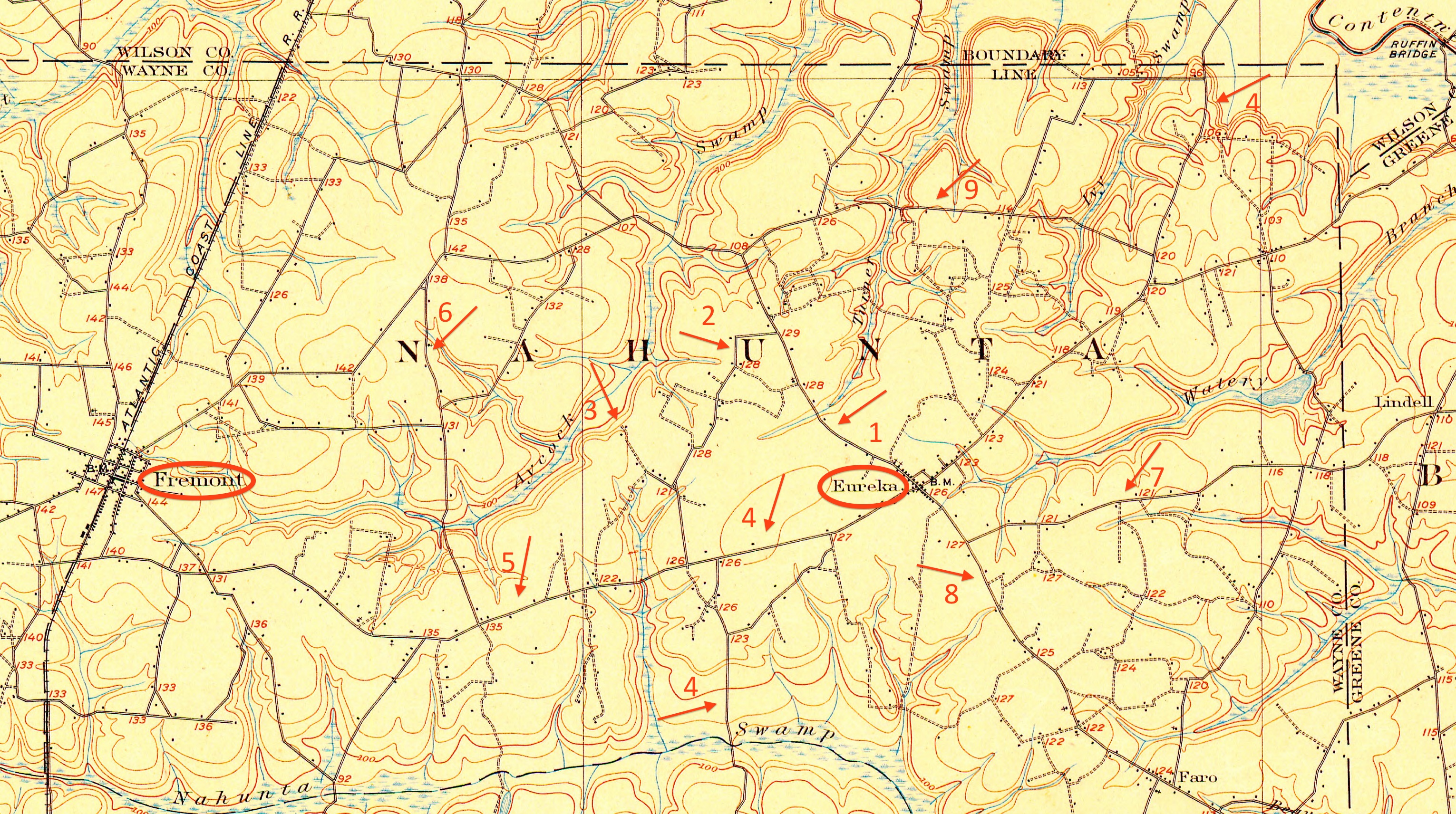
1. Turner Swamp Road runs from the crossroads at the center of Eureka northwest to dead-end at Davis Mill Road (9). Jonah Williams‘ church is on this road, and his brother Richard Artis’ family were among early members.
2. Reidtown Road arcs to connect Highway 222 and Turner Swamp Road. It is named for the community formed by the Reid family, free people of color who settled here as early as the 1830s and intermarried with Artises.
3. Napoleon Road, a spur off Reidtown Road, now cuts across Aycock Swamp to meet Davis Mill Road. It remains unpaved, and the only house standing on it is the one Napoleon Hagans built in the 1870s or ’80s. I believe the speck to the left of the road’s end on this map is Hagans’ house.
4. NC 111, which runs with NC 222 northeast to NC 58 at Stantonsburg in Wilson County.
5. NC 222.
6. Black Creek Road connects Fremont (via its Old Black Creek Road spur) and the town of Black Creek in Wilson County. (Black Creek was once the northernmost section of Wayne.) The road is called Frank Price Church Road in Wilson County.
7. Lindell Road runs from Faro Road (8), just south of Eureka, east into Greene County’s Bullhead district. Much of Adam Artis‘ land lay between NC 111 and Lindell Road.
8. Faro Road, the continuation of Turner Swamp Road, runs south from Eureka toward the unincorporated community of Faro, famous as the site where two hydrogen bombs dropped when a B-52 broke up in flight in 1961.
9. Davis Mill Road arcs from Fremont as the northernmost east-west artery across Nahunta.
