
This is what dirt looks like where I’m from. It is not the plush black alluvial loam of the Mississippi Delta or the thin, rock-bedeviled soil of New England. It looks, mostly, like sand. Like in this graveyard, just south of Stantonsburg, Wilson County, where some of my Hall collateral kin lie. 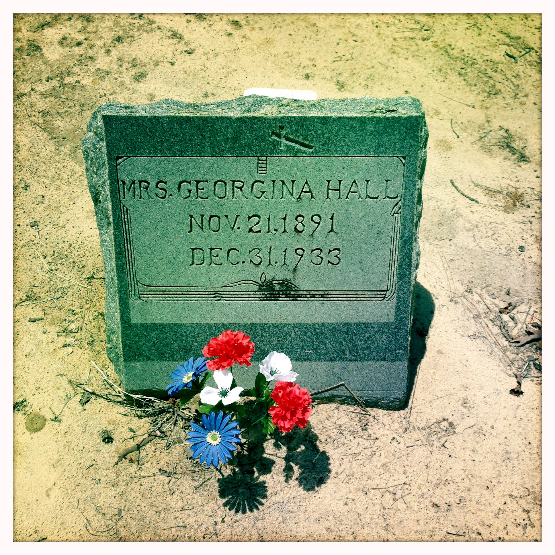 The landscape of my childhood was level. Pine trees and flatness. Devoid, I thought, of any markers of geographical history. No boulder-strewn outcroppings, no foreboding hills, no deep-cut canyons. However, to the contrary, the most obvious relic of deep time was right under my feet.
I grew up on the western edge of North Carolina’s Coastal Plain, which was once the ocean floor. What looked like sand thrown up into the heels of my sneakers in fact was. The story wasn’t quite that simple though. I recall that patches of dirt in some places — like my parents’ back yard — are a pale gray, while others are the soft yellow of the Hall graveyard or, in veins here and there, the rusty-red of clay.
A few days ago, I found a soil survey map of Wayne County, North Carolina, dated 1916. Wayne, where my father’s mother’s people have lived since beyond memory, is just south of my home county. Seldom do I visit my parents that I don’t hop in the car for a quick dip down there. It’s a mere ten miles to the northern corner where my Artises and Haganses and Seaberrys lived, and just another 30 to get down to Dudley, where my Hendersons and Aldridges took root. What could this map, with its colorful camouflagey swirls of color, tell me about their land? The soil from which they pulled sweet potatoes and collards and the cotton and tobacco that put money in their pockets?
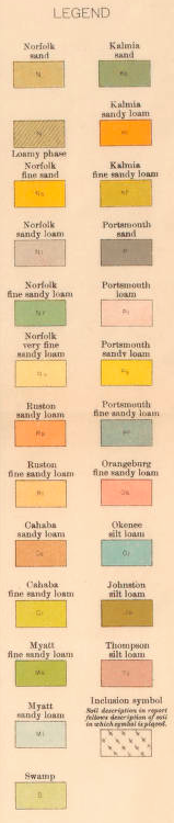
Here’s Nahunta, with Fremont at far left and Eureka at right. The road crossing from edge to edge is now known as Highway 222, and I have cousins that still live on it. That brownish sickle under N A H is marked S, which the key tells us is “Swamp.” Specifically, this is Aycock Swamp, upon whose banks Napoleon Hagans built his house. Another bit of S juts between U and N — that’s the tail end of Turner Swamp. And reaching in from Greene County is the swamp that envelops Watery Branch.  Just below Eureka is a blob of Nv, “Norfolk very fine sandy loam.” The greenish Nf that dominates the frame is “Norfolk fine sandy loam.” This is Adam Artis territory. The pale lavender-gray that washes across the middle is plain “Norfolk sandy loam,” Nl. The only color left in the areas in which my family lived is the sliver of peach that hugs the south side of Aycock Swamp — Ps or “Portsmouth sandy loam.” What is all this?
From a very helpful PDF linked to the pittcountync.gov website: “The Norfolk series consists of well-drained, nearly level and gently sloping soils on uplands. These soils formed in Coastal Plain sediment. A seasonal high water table is below a depth of 5 feet. In a typical profile, the surface layer is dark grayish-brown and light yellowish-brown sandy loam about 10 inches thick. The subsoil is olive yellow and brownish yellow to a depth of about 84 inches. In the upper part, the subsoil is friable sandy clay loam mottled with red. In the lower part, it is friable sandy loam mottled with red and gray. Natural fertility and the content of organic matter are low, and available water capacity is medium. Permeability is moderate, and shrink-swell potential is low. In areas that have not received lime, reaction is strongly acid or very strongly acid. The Norfolk soils of Pitt County are important for farming. Slope is the major limitation to their use. Most of the acreage is cultivated or in pasture. The rest is chiefly in forest and in housing developments or other nonfarm uses. Where crops are grown, response is good to recommended applications of fertilizer and lime.” (Pitt County is on the other side of Greene from Wayne County.)
From the same source: “The Portsmouth series consists of very poorly drained, nearly level soils on stream terraces. These soils formed in alluvial sediment. A seasonal high water table is at or near the surface. In a typical profile, the surface layer is very dark gray and very dark grayish-brown loam about 15 inches thick. The subsoil is about 24 inches thick. The upper part is grayish-brown, friable sandy loam mottled with grayish brown. The lower part is grayish-brown, friable, sandy clay loam mottled with yellowish brown. Below the subsoil and extending to a depth of about 68 inches is grayish-brown and light brownish-gray sand and coarse sand. Natural fertility is low, and the content of organic matter and available water capacity are medium. Permeability is moderate, and shrink-swell potential is low. In areas that have not received lime, reaction is strongly acid or very strongly acid. The Portsmouth soils in Pitt County are of only minor importance for farming. Major limitations to their use are the seasonal high water table and frequent flooding for brief periods. Most of the acreage is in forest, and the rest is chiefly in cultivated crops or pasture. Where crops are grown they respond well to recommended applications of fertilizer and lime.”
These flat acres of mostly Norfolk series soil, then, with liberal amendment, were much better quality farmland than I would have supposed.
The same was true in Brogden township, at the other end of the county. Today’s major roads, two-lane 117 Alternate and four-lane 117, which roughly parallel the railroad to the west, did not exist in 1916. (In fact, what is now Highway 117 was cut through well into my adulthood.) The railroad is still there, though, as is the road (now called O’Berry/Sleepy Creek Road) that crossed the tracks at Dudley’s little heart. Some of the little black specks you can barely see marked my people’s houses. I know, for example, that Aldridges lived along the railroad among the little dots marked opposite COAST. And the Congregational Church cemetery was just below Yellow Swamp, the shallow branch in which my people were baptized.
 The Hendersons and Aldridges and their related families, Simmonses, Wynns, Manuels, and Jacobses among them, lived within a few miles’ radius of Dudley. The soils they wrestled with included Norfolk sand (N), Norfolk sandy loam (Nl), Portsmouth sandy loam (Ps), and Ruston sandy loam (Rs). The same basic dirt as in the north of the county, with the addition of the Ruston, defined here: “The Ruston series consists of very deep, well drained, moderately permeable soils that formed in loamy marine or stream deposits. These soils are low in fertility and within the root zone have moderately high levels of exchangeable aluminum that are potentially toxic to some agricultural crops but are ideal for the production of loblolly, slash, and longleaf pine. The soils have slight limitations for woodland use and management.”
